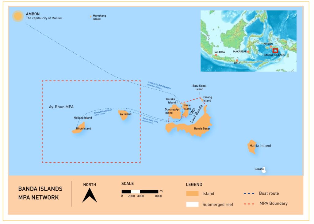
Banda Islands MPA Network
Marine Life & Environmental Threats
Surveys have identified 397 hard coral species, including the endemic Acropora desalwii, and 739 reef fish species, placing the Banda Islands among the top Asia-Pacific sites for biodiversity. Notable residents include the tiny, colorful mandarin fish and endangered Napoleon wrasse, with wrasse populations described as remarkably high compared to heavily exploited regions. Unique volcanic geology, steep drop-offs, and nutrient-rich upwelling shape habitats from reefs to seamounts. Surprisingly rapid coral colonization of lava flows following the 1988 eruption of Gunung Api drew widespread attention to these reefs.
The islands are an important migration route and feeding ground for oceanic cetaceans, including blue and sperm whales. Seasonal aggregations of hammerhead sharks occur between September and November. Yellowfin tuna fisheries are a significant pelagic resource, and several potential spawning aggregation sites have been identified for large groupers, snappers, and Napoleon wrasse.
Threats such as blast fishing and cyanide poisoning have been recorded, and overfishing endangers groupers, snappers, and spawning aggregation sites. Solid waste from ferries and villages, discharges from markets and harbors, and plastic pollution degrade water quality and coral reefs, especially near jetties and markets. Despite being illegal, coral mining persists to supply building materials. Declining community involvement and uneven tourism benefits reduce incentives to safeguard marine resources.

Location Map
Management & Conservation through Collaborations & Partnerships
CTC works with local communities, authorities and partner organizations to combine traditional knowledge with modern conservation tools. In the Ay–Rhun MPA, zones designate core “no-take” areas, sustainable fisheries, and marine tourism. Indigenous sasi—seasonal fishing closures and rotating area restrictions—is being revitalized and integrated with the zoning system.
Regular Reef Health Monitoring is conducted by CTC with partners to document coral cover, fish abundance, and biomass—crucial for evaluating MPA management effectiveness. In addition, regular Resource Use Monitoring surveys in collaboration with government agencies and local communities strengthen law enforcement, promote sustainable practices, and discourage harmful activities by local fishers and the private sector. Fish spawning aggregation (SPAG) monitoring targets sites vulnerable to exploitation, and socioeconomic and perception surveys provide evidence for design, zoning, and adaptive management.
CTC builds capacity through training in marine monitoring, surveillance, and cetacean conservation and supports the women-led Banda Aware initiative, encouraging sustainable building practices that reduce coral and sand mining. Women’s leadership has been further strengthened through waste management training on Rhun Island, conducted in partnership with Yayasan Cahaya Samudra and local government, with women’s groups trained in recycling, composting, and upcycling. The Banda Deep Sea Snapper (DSS) Pilot Project (2022–2024) trained stakeholders, documented fishing fleets, and identified target species to support more sustainable fisheries.
Kalesang Banda Project
The Kalesang Banda Project aims to strengthen MPA management, safeguard endangered, threatened, and protected species, and enhance community well-being across the Banda Islands. Funded primarily by the Blue Action Fund and implemented by CTC, the five-year initiative (2025-2030) is delivered with MMAF, the Maluku Provincial Government, Baileo Maluku Foundation, LPPM Maluku (Sahari), and Hatfield Indonesia. The program builds capacity for MPAs and OECMs, diversifies livelihood opportunities in the blue economy, and promotes community compliance with sustainable fisheries practices. Lessons from Banda will inform future models for effective MPA and LMMA management across Indonesia.
Learning & Impact
The Banda Islands MPA Network serves as a practical model for integrating local wisdom and science. A marine tenure study led by CTC with national government research partners and Pattimura University documented historical practices to inform management and strengthen the role of sasi. Multi-stakeholder collaboration—government, communities, women’s groups, and civil society—has been central to building institutions capable of implementing zoning and surveillance, monitoring ecosystems, and adapting to change.
Banda’s cultural landscape and seascape generate opportunities for community-based ecotourism. The network is exploring mechanisms—such as visitor fees—to fund conservation and local development while reinforcing stewardship. Lessons from Banda’s zoning of resilient reefs and upwelling areas, protection of spawning sites, revitalization of sasi, and targeted programs such as SPAGs and DSS monitoring, women-led waste initiatives, and Banda Aware are transferable to other MPAs facing similar challenges.
The archipelago’s historic significance—recognized nationally and included on UNESCO’s Tentative List in 2015—adds visibility to conservation messages and can help align cultural pride with marine protection. Together, these elements demonstrate how biodiversity conservation, local livelihoods, and heritage values can advance in tandem.

Learn More
Resources

